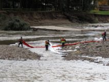
By Friday afternoon, October 21, around 4pm, the general public in the Lewisburg area was starting to get an inkling that something was going on with the river and a fuel spill of some kind. There had been some minimally informative robo-calls from PA American Water, the local water company. And social media accounts from environmental activists whose homes happened to have a front row seat for the flooding were starting to get word out. A few meteorological science enthusiasts had been following the massive amount of rain that fell the night before, but there was a lot of confusion and misinformation, which official channels did not help much to dispel.
What we do know:
- Thursday night a huge amount of rain fell on the Loyalsock Creek watershed, between 6 and 10 inches in under 12 hours.
-
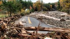
Hoppestown Rd by Hillsgrove. Photo by Barb Jarmoska As might be expected, this massive slug of water rushed through the creek and started giving veterans of Lee and Irene a sense of deja vu.
- Trees, huge amounts of sediment, rock, and eventually parts of the built environment were moving downstream.
- At Wallis Run Road near the settlement of Butternut Grove on the west side of Loyalsock Creek, evacuations were underway by early morning on Friday.
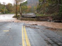
- During this period, the bridge at Wallis Run Road gave way.
- When that happened, an 8" Sunoco gasoline pipeline that ran on the east side of Wallis Run Road along the edge of the Loyalsock and then crossed in the bed of Wallis Run near the bridge, broke.
-
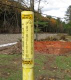
Pipeline markers are everywhere. Photo by Barb Jarmoska As a side note, this was not exactly unexpected since the pipeline was fully exposed during the Lee and Irene floods in 2011. Riprap was placed back around it, but nothing that would withstand the same scouring force again, much less the passage of the concrete deck of the bridge breaking free from its abutments.
- The flow in the pipeline was cutoff some time thereafter (some reports say several hours later). Even had the shutoff been immediate, everything between the shut off valves (almost 10 miles apart) and the rupture would have drained into the creek. The spill is reported at 55,000 gallons though the capacity of that length of line is easily double that figure. Most of the gasoline was swept downstream in the flood. But a lot also settled into the soil surrounding the break. The air in the immediate area has been thick with gasoline fumes for days.
- PA American Water, the local water company, initiated robo-calls to customers in the Lewisburg and Milton area that afternoon. Many received calls around 3pm. However, not all customers were contacted. The call asked customers to engage in conservation and limit non-essential water use in light of the spill. It did not clarify whose water was at risk or which municipal supplies might be involved.
-
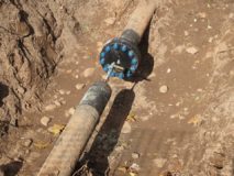
Capped pipeline. Photo by Barb Jarmoska Given the rapidity of the flood, and looking at the flood gauge readings here in Lewisburg, it is likely that the gasoline plume (a long, loosely cohesive zone of water with gasoline spreading along it) started to reach Lewisburg by Friday afternoon. Some eyewitnesses say they smelled it in Lewisburg at 5pm. Given that the spill took some time to flow into the water and had nothing holding it together for its wild ride downstream, it would have continued to flow past for quite some time.
- PA American Water reports that they closed the river intakes to the Milton municipal water supply around 5pm Friday.
- The loose ends of the broken pipe were capped over the weekend and other remediation work (removal of contaminated soil) and construction work (preparation to replace the bridge and restoration of the pipeline) begun. There was also major damage further upstream along the Loyalsock at the community of Hillsgrove, including two houses entirely destroyed.
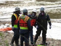
The long-term effects of the gasoline spill are not yet known, and we will need to keep an eye on things. The flood was vigorous enough that a lot of the spill was quickly flushed away from the spill site which means it was dispersed throughout the downstream region. Gasoline is also volatile enough that a large quantity just went up in fumes into the air we all breathe. There is still gasoline soaked soil on site and that's why dams and booms are in place now. There is little recourse for the air quality impacts in the immediate area, and there is no remediation available at the scale of the river. On the one hand, the flush was very effective at diluting the issue, however, this should call our attention to a number of key points we do have some control over going forward:
1) We have a lot of vulnerable infrastructure, much of which we are only vaguely aware of.
2) We have a dire need for more proactive emergency response; it is fortunate that we are prepared to evacuate people in the moment and contend with aftermath, but some thought in advance could have shut down the pipeline ahead of time.
3) Our communication systems for these situations also need work. Everyone downstream should have been notified of the spill far more promptly and in clearer terms.
4) The public education materials the water companies are required to provide to customers leave a lot to be desired. It is almost impossible to have a clear idea as to whose water supplies were compromised by the spill. The messaging used only begged the question of why conservation was a useful response and made everyone wonder what actually was actually being done by those whose job it is to take meaningful action.
The Climate Change impact report for Pennsylvania updated by the state climatologist in 2015 indicates that we can expect more frequent more intense rain events (and also more droughts). So it should not be too much of a surprise that we had a smallish storm, unassociated with any larger system, that managed to dump as much as 8 to 10 inches of rain over a small area right in the Loyalsock watershed last Thursday night. This has not been common in the past but we can expect it to be more common in the future, not there but anywhere. That same amount of rain falling pretty much anywhere around here would create a lot of problems. 5 miles further east and Muncy would have been hit. If it had dumped near in the Bull Run/Limestone Run watershed, we would have been facing some severe impacts in Lewisburg. We are all more vulnerable than ever to events like this. If there were intense rainfall of this sort over a larger area, we would then likely be dealing with a whole series of simultaneous acute issues.

