PennDOT is working through its Twelve Year Plan process which includes having the Surface Transporation Commission solicit public input about transportation every other year. You may recall having done an online survey similar to this the last time around. At the same time, the format has changed somewhat. And our preparation for it is also updated. Since the last time, Walk It! Bike It! Lewisburg has been assessing our local issues and priorities in some depth. Some of those are oriented to advocacy and awareness, but many are also about needed improvements. In turn, some of the desired improvements have to do with local roads and local municipal oversight, but there are also many that involve state roads which are in PennDOT's purview. We have compiled here a list of the state road
issues that you may want to keep in mind when you are completing the survey. It's a long list and not everyone is likely to have the time or patience to log all of these. We hope you will consider them when you weigh in. They are organized by theme/location and the ones that are most critical are shown in bold.
Here's the link to get to the survey: survey.talkpatransportation.com/#/Survey It will ask you about what you consider to be reasonable spending allocations and the most critical topics. The final portion is an interactive mapping section which allows you to zoom to anywhere in the state and place a marker where you would like to register an issue. The deadline to complete the survey is April 19, 2017
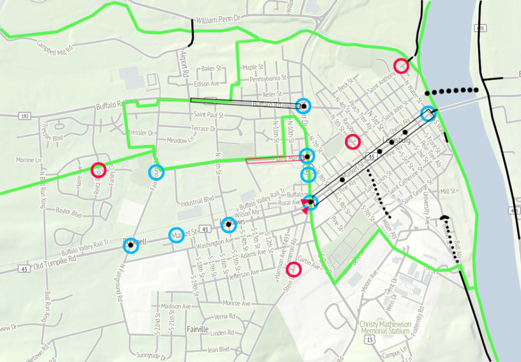
Here is a list of the Lewisburg Area State Road Priorities as identified over the past two years by WIBI:
Route 15 Corridor
- BVRT/Rt 15 intersection - Local transportation engineering studies have identified a need for an at grade signalized intersection with a protected refuge island in the median to permit users of the Buffalo Valley Rail Trail to move from the trail on one side of the highway to the other. This is a critical connection point. Residents on both sides need to be able to connect to destinations on the other side for work, school, commerce, etc.
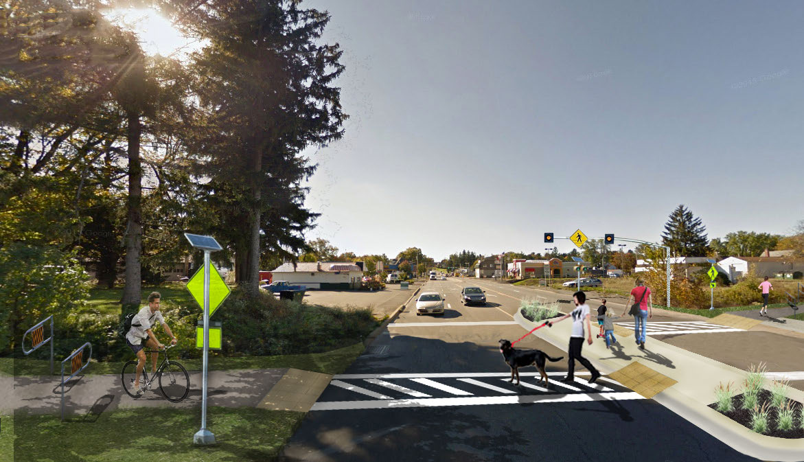
- 15/45 – check “This is a corridor” box to refer to all intersections on Rt 15 in the Borough (45, St Mary St, and 192) -- This is a major and necessary crossing for bikes and pedestrians. There are conflicts with turning traffic and people crossing with the walk signal on a daily basis.
- Rt 15/Hospital Dr/River Rd North - This should be a major bike and pedestrian connection with destinations and residences on both sides of the highway. It is signed in a fashion which makes it unclear if pedestrians area allowed to cross and it is not at all accommodating to either bikes or peds.
- Rt 15/Beagle Club/River Rd South - This could be an important bicycle and pedestrian crossing of the highway given the major residential area to the west and the major destinations to the east, but the crossing is very difficult and unsafe.
Route 45 Corridor in Downtown Lewisburg Borough (Highest Existing Concentration of Bike/Ped Traffic)
- 3rd St and 45 -- check “This is a corridor” box to refer to all signalized intersections on Rt 45 in the Borough (7th, 4th, 3rd, 2nd) - The pedestrian signals are set in such a way as to encourage people to press the button for the walk and then walk with green long before the walk comes around (it can be a wait of 2 1/2 minutes) at which point there are cars sitting at a red on both roads and no pedestrians crossing. The solution would be to redesign the signal so that either a walk with green with a leading pedestrian interval occurs with every round of every cycle or at least on request a walk is offered between the green light for either road (twice/cycle).
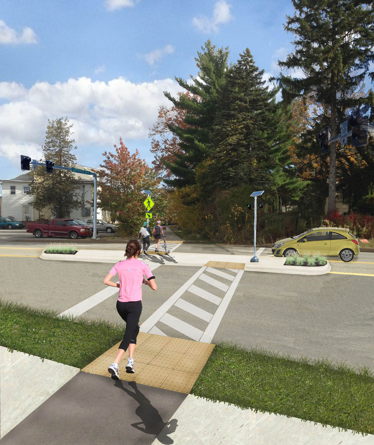
- 6th St and 45 -- check “This is a corridor” box to refer to all unsignalized intersections on Rt 45 in the Borough (8th, 6th, 5th, Front, Water) - The intersections need more visiblity, lighting, signage, and compliance. Some of these solutions would be best implemented in the PennDOT right-of-way, in the form of lighted bollards at the curbs and possibly embedded lights in the pavement. Even better would be lights that flash on request by a pedestrian.
- Market/N Water St - The existing turning lane increases vehicular speeds where they should be decreasing. It is unsafe for pedestrians and yet the gateway to a pedestrian area (and to the river). In addition to removal of the turning lane, it could use an on-demand flasher to increase pedestrian visibility.
Buffalo Creek Crossings (Lewisburg Borough/Kelly Township boundary)
- St Anthony/River Road/Buffalo Creek Bridge - The existing sidewalk on the downstream (S) side of the bridge is useful for fishing but not useful as a pedestrian connector. There are significant residential and recreational areas on both sides of the creek, but they are cut off from each other by the lack of a sidewalk on the upstream (N) side of the bridge. There are other locations to fish from in the area, but no access for bikes and pedestrians across the creek, so future work on the bridge could include shifting the sidewalk from the current side to the north side in order to connect the core of Lewisburg Borough with the AYSO soccer fields and RiverWoods retirement community.
- Rt 15/Buffalo Creek Bridge/near William Penn Dr - Pedestrians and Bikes regularly move from south of Buffalo Creek to north and back with residences and destinations on both sides. There are few crossings and none of them accommodate bikes or pedestrians properly (here, Airport Rd, and River Rd). This would be a reasonable location for a bike/pedestrian bridge over Route 15. The topography would be conducive to it, allowing for reasonable access points on either side.
- Airport Rd bridge over Buffalo Creek - There are only three possible crossings of Buffalo Creek in the community and none of them accommodate pedestrians or cyclists. This location will be even more critical in coming years because the district high school was just relocated on the north side of the creek, while the bulk of the densest population of the district lies just to the south of the creek. This bridge also aligns with an access lane into the new school property and should be developed as part of a new safe route to school.
Route 45 Corridor in East Buffalo Township and Buffalo Township
- Rt 45 crosswalk at schools -- This crosswalk serves the two schools one block south of Rt 45, but there is very little compliance with the required yield to pedestrians. It needs more visibility and perhaps the entire corridor to shift to 25mph speed limit rather than the current 35mph, with intermittent school zone.
- Fairground/45 - check “This is a corridor box” to refer to all intersections on Rt 45 in EBT (Fairground, Bull Run Crossing, Fairfield, Hoffa Mill) -- This is a major access point to the Buffalo Valley Rail Trail for pedestrians and cyclists who live to the south. It is a very dangerous, high speed, and poor visibility intersection with no markings or accommodations for crossing traffic not in a vehicle.
- 15th St/Rt 45 - The new signals are very hard to trigger for a person on a bicycle. There should be a clearly marked location to stop and be caught by the cameras if there are no cars waiting to cross.
- Rt 45/Ard’s Farm Lane - This is a potential major access point to the Buffalo Valley Rail Trail. It is a high speed location but has better visibility than the nearby intersection at Hoffa Mill Rd. The speed limit which is 45 in the Lochiel area to the east should extend further, a crosswalk should be marked and signed. This location has better visibility and no turning traffic to contend with.
Internal East Buffalo Township
- Fairground/BVRT - This is an intersection at a high traffic and low visibility location which sees large numbers of pedestrians and cyclists on the trail and large numbers of cars on the road. Cars stopped for the light on Rt 45 queue up well past the trail crossing on a regular basis. Cars coming from the direction of Rt 45 tear past without regard for the thought that a bike or ped might be trying to cross. This is particularly problematic as it is a good route for access to two of the district's schools, plus the intersection is adjacent to a major year-round, weekly produce auction.
- St Mary St and Fairground Rd - This is a needed bicycle and pedestrian connection between residential areas on both sides and destinations on both sides, like the public library, parks, grocery stores, etc. There are no crosswalks, a wide roadway, and high speed traffic. Visibility is reasonable, but there is an expectation that pedestrians and bikes should not be there. Their legitimate claim to the road and right-of-way should be visible and explicit.
West Chilisquaque Township
- Railroad bridge across the Susquehanna - The Buffalo Valley Rail Trail (constructed as a TAP project) should continue across the old railroad bridge over the Susquehanna. This is currently a trail gap between Union County and Northumberland County. Even without reaching Rt 405, the bridge would be a major recreational destination and would complete (with the Rt 15 crossing) the full potential of the rail banked property obtained from the North Shore Railroad.
- Rt 405 north of 45 - This could be a major artery/connector for people on bicycles, but even with the wide existing shoulder, the separation from high speed traffic is minimal. It can work for experienced and mature cyclists, but the location could be promoted for recreational cyclists if it were laid out in a safer fashion.
- Rt 405 south of 45 - This could be a major avenue for people on bicycles and on foot to reach important destinations along the river, like farm stands, restaurants and a boat launch, but even with the existing shoulder, the separation from high speed traffic is minimal. It can work for experienced and mature cyclists, but the location could be promoted for recreational cyclists if it were laid out in a safer fashion.
- Rt 45/405 intersection - There are limited pedestrian accommodations on one corner of the intersection but in reality the intersection should be able to help pedestrians and cyclists to connect from Lewisburg Borough to Old Route 45 (and 405 north or south with future improvements). This is a regular route for bird watching, walking, and general recreation, but it is very hazardous to navigate this intersection without a car.