The actual floodwaters may have receded from the most recent brush with waterside living risks, but the reality of our community's exposure to that risk is ongoing -- even on dry and sunny days. This latest flood (July 2018) was not actually all that high, cresting at Lewisburg on the river just below 18' above flood stage. But it put the Borough crew into high gear, disrupted the week for the Buffalo Valley Rec crew, and put a lot of plans on hold for groups like the Heiter Center Summer Camp -- not to mention all the private chaos for river-proximate property owners.
During the event, we shared a variety of links on facebook to help people keep abreast of what to expect. These are links that are already housed on our site in the gallery area under Flood Impact Task Force, but the actual heat (or wet) of the moment crystallizes the urgency of some knowledge. So I'm compiling here the most helpful (in this past event) of the sites.
Flood Gauge
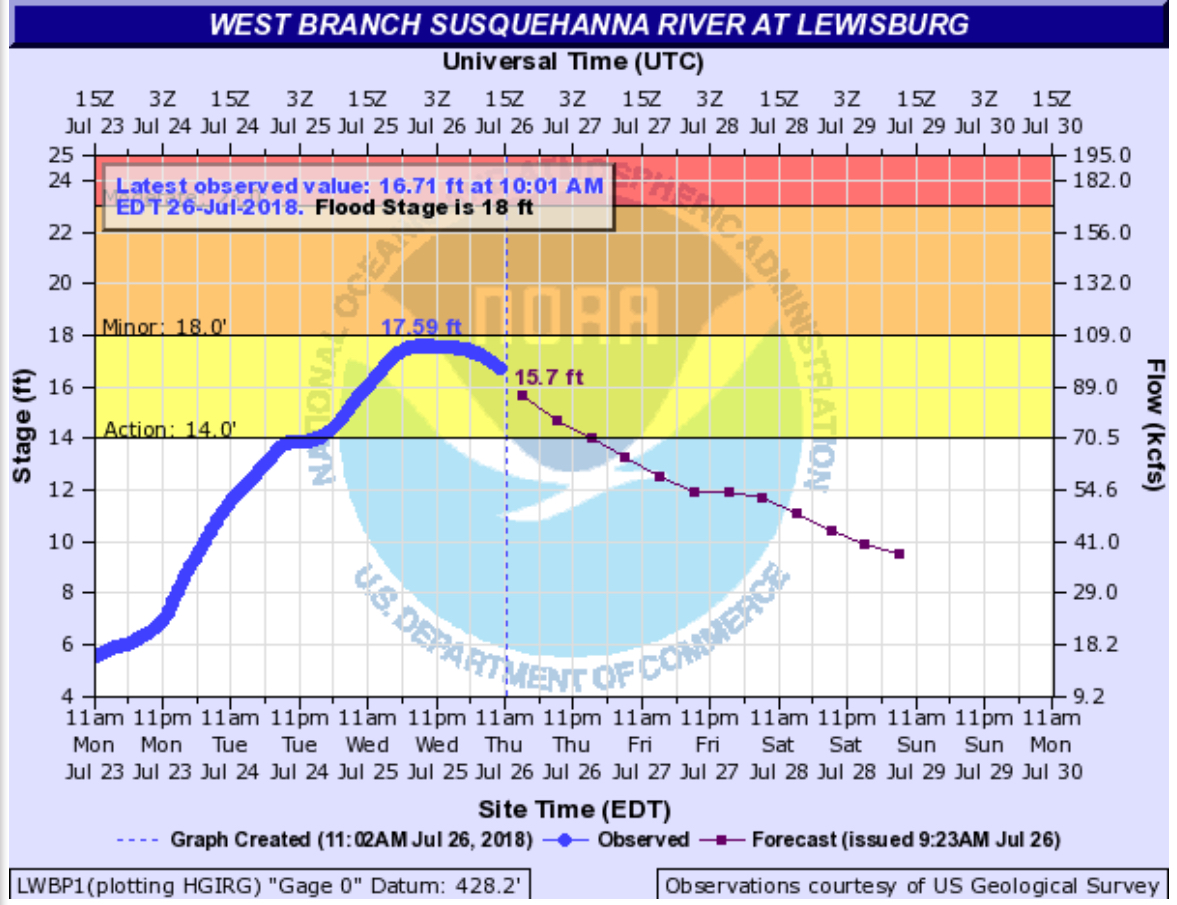
Everyone wants to know how high it's going to go and we are lucky to have a USGS flood gauge at the bridge here in Lewisburg. This hydrograph hosted on the National Weather Service gives us a wealth of information, including helpful predictions as to time and likely height of crest. It's a dynamic system and the rain is variable, so it changes over time. Early on it showed potential local cresting above 20', but given the actual amount and location of the rainfall, that adjusted over time. This is also useful information when you're planning to go kayaking or hold a river cleanup... So keep it bookmarked.
River Stage Food Extents
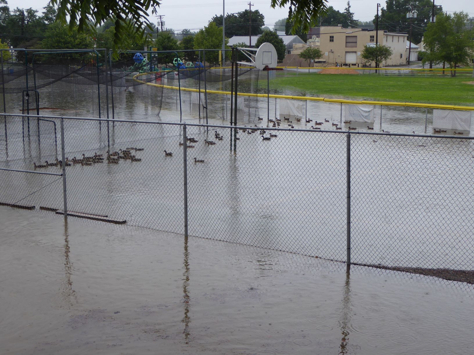
The Union County GIS office has compiled a series of maps illustrating the approximate extents of river flooding every 2' from 20' to 36'. During this past event, the map of the 20' extents was relevant and circulated. It should be noted however, and we saw this clearly during this event, that the map is based on river flooding alone and Lewisburg has two additional waterways capable of causing mischief. So, in addition to the water backing up from the river, the contributions of Limestone Run/Bull Run also made a bit of a mess at Danny Greene Field, the Giant wetlands, and the Lewisburg Area Recreation Park. Why wasn't that shown on the map? Because that was a result of creek flooding which we simply don't have as much information about, either in terms of advance forecasting or immediate reports. Now we can all appreciate the uncertainty embedded in the saying: "God willing and the creek don't rise."
Historical Context
There are notes on the NOAA site about previous flood events, but for a more comprehensive and at a glance record, this pdf is much more useful. You will note that this past event is high for the past few years, but also that we had four events in the vicinity of 20' in 2010 and 2011 and that doesn't include the near 24' crest from Irene/Lee in September 2011. For reference, the great floods of '36 and'72 were in the vicinity of 34' -- at which point downtown Lewisburg is an island with a tenuous connection to the mainland only along the railroad tracks.
Act Now!
A brush with flooding is a good reminder to take action and consider how to mitigate risks where possible. As it happens the FEMA Silver Jackets program is offering a workshop for the general public in Lewisburg coming up on Wednesday, August 15, at 6:30pm at the Union County Government Center on N 15th St. It's free to attend, but they do request the courtesy of an RSVP through eventbrite here. The workshop will focus on floodproofing techniques and will be most relevant to people living and/or owning property in the 100 year floodplain. That said, people in the 500 year floodplain should not consider themselves immune. In fact, people not in floodplains are often at greatest risk during crisis flood events precisely because they have no plan in place. Recent years have seen flooding of properties outside floodplains in TX (Houston), LA, SC, NC, and even in the hills above the Loyalsock Creek two years ago.