
 The slideshow for the River Town Planning Charrette in the spring of 2016 can be downloaded as a pdf here: Lewisburg -- River Town CharretteLORES. It's a large file (18.7M) with a great deal of maps and images included. What follows is a synopsis of what was reviewed in the presentation.
The River Town project has been underway in Lewisburg since 2014, coming initially out of interactions with residents of the North Ward Neighborhood. By fall of 2014, the Borough had applied and been recognized formally as a river town by the Susquehanna Greenway Partnership. It represents a partnership between the Borough, the LNC, the Lewisburg Downtown Partnership, and the Buffalo Valley Rail Trail/Rec Authority.
We know we’re a river town on a certain level, it’s pretty fundamental. And yet, the river actually shows up as an absence on many maps, as if Lewisburg were on the edge of the world. It’s outside the municipal jurisdiction after all. And out of sight, out of mind… So while we are a river town, the river is currently mostly for those in the know. We do have a number of events and activities sited there, and we are working on increasing awareness and opportunities to interact. And yet, there still is an aura of mystery and confusion about what/where/who/how/why... There are few signs, there are few paths, there are few sidewalks, there are few maps… It’s hard to make the most of this amenity without having in place ways to share it with friends and neighbors who may not be as motivated, much less to show it off to visitors to our area.
We have elements of the river included in the Heart of Lewisburg Ice Festival, with the Polar Bear Plunge, and this year, with the Celebration of the Arts having the river as its focus. But absent those events, a visitor to the area would be hard pressed to find their way to the river if they happened to light out for it from the center of town. And even if they made it, they might wonder, with the lack of fanfare and accommodations, whether they were in the right place. It seems to be more of an insider experience. This is your invitation to think about how and where best to engage residents and visitors.

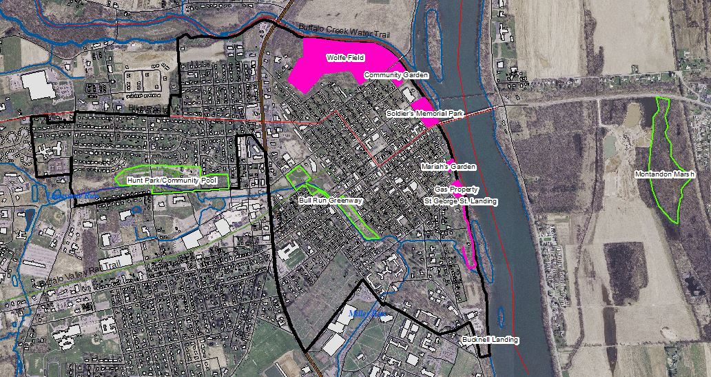
Some of us just did a tour along several of the sites and we have on hand lots of site images and maps. These maps help remind us of how being a river town is about more than just a laser focus on that waterway. It also has to do with trails and tributaries that connect that central spine to the larger landscape. So we have site information about Montandon, and the Buffalo Valley Rail Trail, and we’ll also be making mention at least in passing of what’s happening to the north and south in Kelly and East Buffalo Townships respectively.
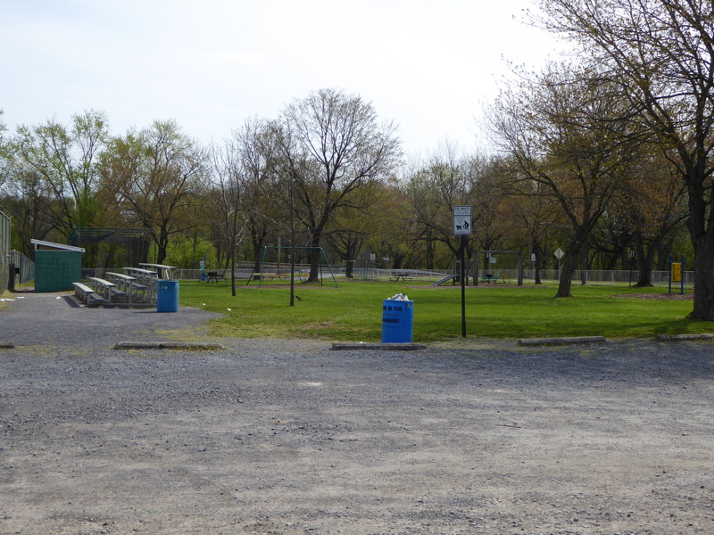
Right now, I want share some information with you about the extents of the area/sites we’re looking at, what used to be in these areas in the past, including consideration of the things that are less well-documented, and reviewing the future – looking at proposals that have been made but not yet realized for areas along the river. We are concerned specifically with the public land along the river within the Borough. That includes Wolfe Field, the Community Garden, Soldiers Memorial Park, Mariah's Garden, and the St George St Boat Ramp/Gas Property area. There is also a trail easement south of St George St, but it is on private property. It was set up by the County in the late 80s and needs a fair amount of attention to figure out and ensure its future.
But first, how does this relate to the Bull Run Greenway Project?
We are engaged in planning, just like the Greenway Project. But we’re behind by about 10 years. So right now we are trying to get into position to be able to work together as a community (as we have been in the Bull Run area) and move toward applying for grants to get some projects going. But what projects? That’s what this evening is about. There are so many possibilities; there are so many existing proposals, we are hoping in part to get a better sense, through the charrette and the survey both, of where public sentiment lies. Otherwise, we wind up with planning by neglect, semi-random grasping at low-hanging opportunities, and uncoordinated (and therefore often less successful) bids for funding.
The goal of the River Town Team is to better connect the community to the river both physically and culturally. Once we were designated as a river town, we held a major public meeting in fall of 2014 and coming out of that we identified four major focus areas: Events/Awareness, Conservation, Connectivity, and Planning. We also noted that it would be critical to conduct assessments of the broader community’s current attitude toward the river (beyond the North Ward Neighborhood and those willing to jump in early on in getting the operation off the ground). Committees have been meeting regularly since then to move the first three categories forward. The final category got a big break this semester when three Bucknell seniors in the ENST 411 capstone course chose to work on River Town Planning. They have been assembling background materials, assessing public attitudes, checking in with key organizational partners, publicizing this event, and supporting the activities during the event.
A critical element of the process has been – and will continue to be – the River Town Survey now being circulated by the students. The students will now present to you a summary of the responses to date to the survey. We have almost 200 responses in, but we hope to get many more in the next few weeks. The survey can be found and completed online or as a hard copy in the Borough Office, where print copies can also be dropped off when completed.
Thus far, the survey results confirm that there is more interest in accessing the river than actual access, largely due to lack of facilities. They also indicate that we are of two minds about the river, both seeing it as the "lifeblood of the region" and "the spirit and soul of Lewisburg" and "endangered," "underutilized," "forgotten." The top priority activities are biking, walking/jogging, and canoeing/kayaking, with other uses such as bird watching, fishing, and boating coming in somewhat lower. In terms of what people perceive to be the biggest threats to Lewisburg from the river, it was seen as a mix of loss of cultural connection to place, litter, waterborne pollution, and flooding.
Flooding is a major concern – and justifiably so. For many, the river has been too personal a menace to be embraced. And that potential remains, just after the next historic and unfortunately sited downpour. And yet, we need to be both. We need to see this emptied out edge as an opportunity, not a scar or wound, something to favor and shy away from. We need to fill the ample edge with lively recreation and contemplation.
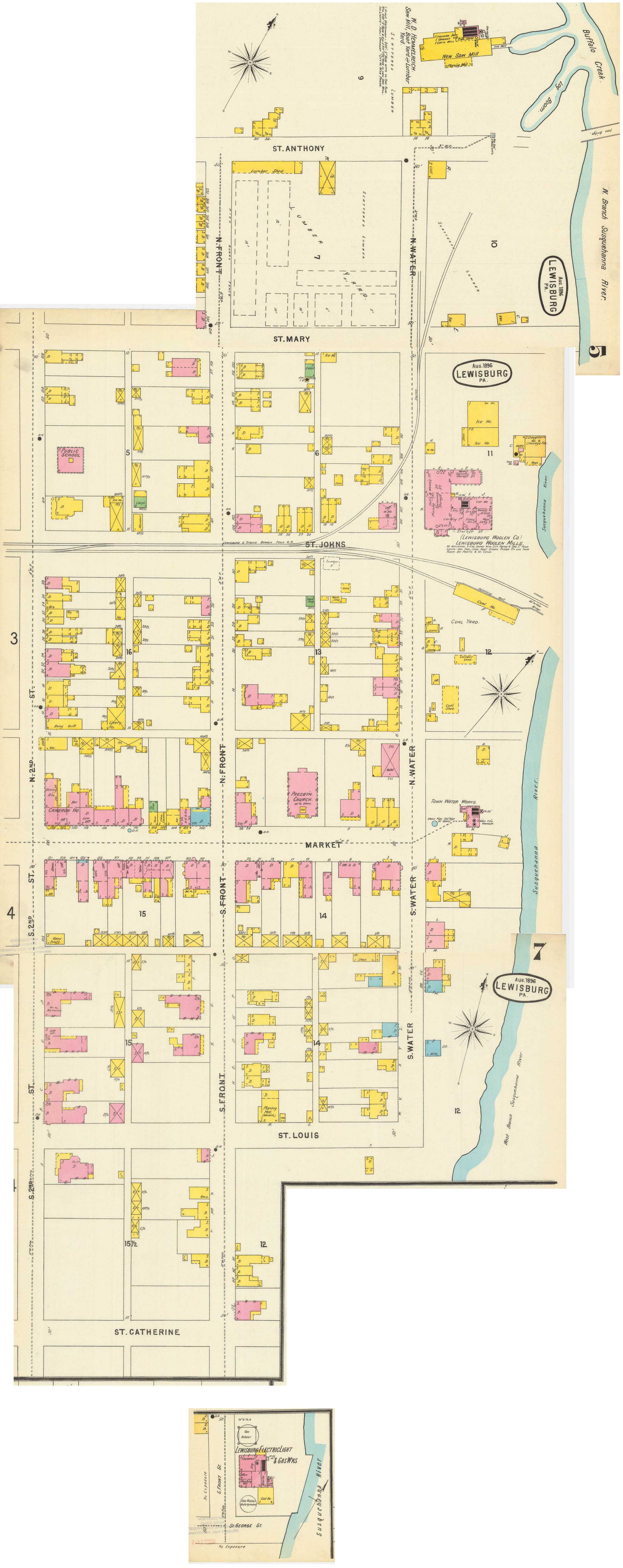
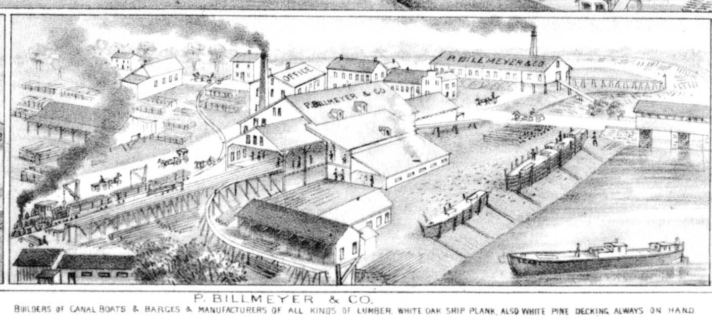
What filled it before? Here are historic maps from various sources. The key thing to note is the presence of lots of industry along the river. We don’t have time to go into the details of everything that was there tonight, but there were lumber mills, canal boat building, coal yards, water companies, woolen mills, gas companies, etc. That has all been removed or displaced, and reasonably so, as it was very vulnerable to the river in raging mode. Plus, the economy has shifted away from local production. Instead, we are a knowledge economy and have lifestyle to market. The river can, could, and should be a key element of that lifestyle.
Tonight you’re also being asked to look at individual sites and just the areas in the Borough, but at the same time to keep in mind the implications of and for the areas beyond, whether immediately across the municipal boundaries, in Kelly, East Buffalo, or West Chilisquaque Townships. Or further afield with potential connectors to Northumberland and Sunbury and further south or north to Montgomery, Williamsport, Loch Haven.
In that vein and in the spirit of inverting a disadvantage, let’s consider what this land is a gateway to. Rather than buying into the image of the town being at the back edge of beyond, think of it as having Northumberland County out the back door, and specifically as way to engage parts of Northumberland on foot or by bike that are currently really only accessed by car. Take May’s for example. It’s called a “drive-in” but we could walk. What else could we walk to if our sidewalk and connected infrastructure took us there? The Dries farmstand, the Fence, the Montandon Marsh, the once and future restaurants to the north, migratory waterfowl viewing areas, the Chilisquaque boat launch, Milton, Northumberland, and beyond.
Let’s recenter and think of our network extending. Rather than petering out towards the river, the borough could make the most of that solid edge. We can aspire to the advantages of a coastal site, like Miami, or a small town like Yellow Springs, OH, which have edges which juxtapose their cultural centers with natural resources and accessible wilderness. These edges are opportunities. To be able to venture out into the world, without a motor vehicle, and then return to civilization and a lovely thai dinner. Now that’s a destination…
